Cook County, Illinois
| Cook County, Illinois | |
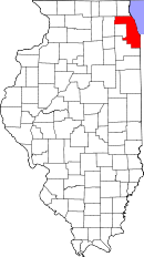 Location in the state of Illinois |
|
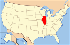 Illinois's location in the U.S. |
|
| Founded | January 15, 1831 |
|---|---|
| Named for | Daniel Cook |
| Seat | Chicago |
| Area - Total - Land - Water |
1,635 sq mi (4,235 km²) 946 sq mi (2,450 km²) 689 sq mi (1,785 km²), 42.16% |
| PopulationEst. - (2008) - Density |
5,294,664 5,597/sq mi (2,161/km²) |
| Website | www.cookcountygov.com |
Cook County is a county in the U.S. state of Illinois. It is the second most populous county in the United States after Los Angeles County. The county has 5,294,664 residents,[1] which is 43.3% of all Illinois residents. Cook County's population is larger than that of 29 individual U.S. states and the combined populations of the seven smallest US states.[2] There are over 130 incorporated municipalities in Cook County, the largest of which is the county seat, Chicago, which makes up approximately 54% of the population of the county. The county is divided into 30 different townships. Geographically the county is the fifth largest in Illinois by land area and shares the state's Lake Michigan shoreline with Lake County.
Contents |
History
Cook County was created on January 15, 1831 out of Putnam County by an act of the Illinois State Legislature. It was the 54th county established in Illinois and was named after Daniel Cook, one of the earliest and youngest statesmen in Illinois history, who served as the second U.S. Representative from Illinois and the first Attorney General of the State of Illinois. Shortly thereafter, in 1839, DuPage County was carved out of Cook County.
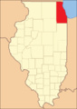 Cook County from the time of its creation to 1836 |
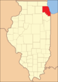 Cook County from 1836 to 1839 |
Government and politics
Cook County's current County Board president is Todd Stroger. The county has by far more Democratic Party members than any other Illinois county, and is one of the most Democratic counties in the United States. It has voted only once for a Republican candidate in a Presidential election in the last forty years, when county voters preferred Richard Nixon to George McGovern in 1972.
The Cook County Democratic Organization is one of the most powerful political machines in American history. Commonly called the "Chicago Democratic machine", or simply the "Chicago Machine", the organization has dominated Chicago politics since the 1930s. Corruption and scandal have frequently been synonymous with the machine.
The Circuit Court of Cook County, which files more than 1.2 million cases every year,[3] the Cook County Department of Corrections, also known as the Cook County Jail, the largest single-site jail in the nation, and the Cook County Juvenile Detention Center, the first juvenile center in the nation and one of the largest in the nation, are solely the responsibility of Cook County government. The Cook County Law Library is the second largest county law library in the nation.
The Bureau of Health Services administers the county's public health services and is the second largest public health system in the nation. Three hospitals are part of this system: John H. Stroger, Jr. Hospital of Cook County, Provident Hospital, and Oak Forest Hospital of Cook County, along with over 30 clinics.
The Cook County Highway Department is responsible for the design and maintenance of roadways in the county. These thoroughfares are mostly composed of major and minor arterials, with a few local roads. Although the Highway Department was instrumental in designing many of the expressways in the county, today they are under the jurisdiction of the state.
The Forest Preserve District, organized in 1915, is a separate, independent taxing body, but the Cook County Board of Commissioners also acts as the Forest Preserve District Board of Commissioners. The District is a belt of 69,000 acres (275 km²) of forest reservations surrounding the City of Chicago. The Brookfield Zoo (managed by the Chicago Zoological Society) and the Chicago Botanic Garden (managed by the Chicago Horticultural Society) are located in the forest preserves.
In the 1980s, Cook County was ground zero to an extensive FBI investigation named Operation Greylord. Ninety-two officials were indicted, including 17 judges, 48 lawyers, 8 policemen, 10 deputy sheriffs, 8 court officials, and 1 state legislator. Cook County is the fifth largest employer in Chicago.[4]
In March 2008, the Cook County Board increased sales tax one percent, increasing the county sales tax rate from 0.75% to 1.75%. This followed a recent quarter-cent increase in mass transit taxing coming into effect in April. In Chicago, the rate increased to 10.25 percent, the steepest nominal rate of any major metropolitan area in America (the actual rate is much lower, as the sales tax does not apply to many items taxed elsewhere).[5] In Evanston, sales tax reached 10 percent and Oak Lawn residents will pay 9.5 percent.[6] On July 22, 2008, the Cook County board voted against Cook County Commissioner's proposal to repeal the tax increase.[7]
| Year | Democrat | Republican |
|---|---|---|
| 2008 | 76.48% 1,582,973 | 23.05% 477,038 |
| 2004 | 70.25% 1,439,724 | 29.15% 597,405 |
| 2000 | 68.63% 1,280,547 | 28.65% 534,542 |
| 1996 | 66.79% 1,153,289 | 26.73% 461,557 |
| 1992 | 58.21% 1,249,533 | 28.20% 605,300 |
| 1988 | 55.77% 1,129,973 | 43.36% 878,582 |
| 1984 | 51.02% 1,112,641 | 48.40% 1,055,558 |
| 1980 | 51.99% 1,124,584 | 39.60% 856,574 |
| 1976 | 53.44% 1,180,814 | 44.69% 987,498 |
| 1972 | 46.01% 1,063,268 | 53.41% 1,234,307 |
| 1968 | 50.56% 1,181,316 | 41.11% 960,493 |
| 1964 | 63.18% 1,537,181 | 36.82% 895,718 |
| 1960 | 56.37% 1,378,343 | 43.33% 1,059,607 |
Secession movements
To establish more localized government control and policies which reflect the often different values and needs of large suburban sections of the sprawling county, several secession movements have been made over the years which called for certain townships or municipalities to form their own independent counties.
In the late 1970s, a movement started which proposed a separation of six northwest suburban townships, Cook County's panhandle (Barrington, Hanover, Palatine, Wheeling, Schaumburg, and Elk Grove) from Cook to form Lincoln County, in honor of the former U.S. president and Illinois resident.[8] It is likely that Arlington Heights would have been the county seat. This northwest suburban region of Cook is moderately conservative and has a population over 500,000. Local legislators, led by State Senator Dave Regnar, went so far as to propose it as official legislation in the Illinois House. The legislation died, however, before coming to a vote.
In 2004, Blue Island mayor Donald Peloquin tried to organize a coalition of fifty-five south and southwest suburban municipalities to form a new county, also proposing the name Lincoln County. The county would include everything south of Burbank, stretching as far west as Orland Park, as far east as Calumet City, and as far south as Matteson, covering an expansive area with a population of over one million residents. Peloquin argued that the south suburbs are often shunned by the city and blamed the Chicago-centric policies of Cook County government for failing to jumpstart the long-depressed local economy of the south suburban region. Pending sufficient interest from local communities, Peloquin planned a petition drive to place a question regarding the secession on the general election ballot.[9]
Talk of secession amongst outlying communities have again heated up in mid-2008 in response to a highly controversial 1% sales tax hike which has pushed the sales tax rate in Chicago proper to 10.25%, and pushed the nominal tax rates across the various other county communities up amongst the highest in the nation (the actual rate is much lower, as the sales tax does not apply to many items covered by sales taxes in other major metropolitan areas, e.g., periodicals).[10][11] Border towns in particular have been outraged, as people can take their business across the county border (paying, for instance, 7% in Lake County instead of Palatine's 11%). In March 2009, advisory referenda in Barrington, Hanover and Palatine Townships passed recommending secession from Cook County.
Geography
According to the U.S. Census Bureau, the county has a total area of 1,635 square miles (4,235 km²), of which 946 square miles (2,449 km²) is land and 689 square miles (1,785 km²) (42.16%) is water, most of it in Lake Michigan. The highest point in Cook County is its northwest corner, at nearly 1,000 feet above sea level.[12]
Major expressways, US and state routes
|
|
|
|
Adjacent counties
- Lake County, Illinois - north
- Lake County, Indiana - southeast
- Will County, Illinois - south
- DuPage County, Illinois - west
- Kane County, Illinois - west
- McHenry County, Illinois - northwest
- Berrien County, Michigan - east (across Lake Michigan)
National protected area
- Chicago Portage National Historic Site
Demographics
| Historical populations | |||
|---|---|---|---|
| Census | Pop. | %± | |
| 1840 | 10,201 |
|
|
| 1850 | 43,385 | 325.3% | |
| 1860 | 144,954 | 234.1% | |
| 1870 | 349,966 | 141.4% | |
| 1880 | 607,524 | 73.6% | |
| 1890 | 1,191,922 | 96.2% | |
| 1900 | 1,838,735 | 54.3% | |
| 1910 | 2,405,233 | 30.8% | |
| 1920 | 3,053,017 | 26.9% | |
| 1930 | 3,982,123 | 30.4% | |
| 1940 | 4,063,342 | 2.0% | |
| 1950 | 4,508,792 | 11.0% | |
| 1960 | 5,129,725 | 13.8% | |
| 1970 | 5,492,369 | 7.1% | |
| 1980 | 5,253,655 | −4.3% | |
| 1990 | 5,105,067 | −2.8% | |
| 2000 | 5,376,741 | 5.3% | |
| Est. 2008 | 5,294,664 | −1.5% | |
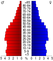
As of the 2000 Census,[13] there were 5,376,741 people, 1,974,181 households, and 1,269,398 families residing in the county. The population density was 5,686 people per square mile (2,195/km²). There were 2,096,121 housing units at an average density of 2,216 per square mile (856/km²). The racial makeup of the county was 56.27% White, 26.14% Black or African American, 0.29% Native American, 4.84% Asian, 0.05% Pacific Islander, 9.88% from other races, and 2.53% from two or more races. 19.93% of the population were Hispanic or Latino of any race. 9.1% were of Polish, 8.1% German, 7.9% Irish and 5.7% Italian ancestry according to Census 2000. 17.63% reported speaking Spanish at home; 3.13% speak Polish.[14]
2005 Census estimates placed the non-Hispanic white population of Cook County at 45.4% of the total population of the county. Other racial groups were African-Americans at 26.4%, Latinos at 22.2% and Asians at 5.5%.[15] 2006 estimates showed the non-Hispanic white percentage of the population at 44.7%.[16]
According to the 2000 Census there were 1,974,181 households out of which 30.9% had children under the age of 18 living with them, 44.0% were married couples living together, 15.6% had a female householder with no husband present, and 35.7% were non-families. 29.4% of all households were made up of individuals and 9.3% had someone living alone who was 65 years of age or older. The average household size was 2.68 and the average family size was 3.38.
In the county the population was spread out with 26.0% under the age of 18, 9.9% from 18 to 24, 31.7% from 25 to 44, 20.7% from 45 to 64, and 11.7% who were 65 years of age or older. The median age was 34 years. For every 100 females there were 93.9 males. For every 100 females age 18 and over, there were 90.5 males.
The median income for a household in the county was $45,922, and the median income for a family was $53,784. Males had a median income of $40,690 versus $31,298 for females. The per capita income for the county was $23,227. About 10.6% of families and 13.5% of the population were below the poverty line, including 18.9% of those under age 18 and 10.3% of those age 65 or over.
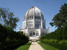
According to Census Bureau estimates, the county's population was down to 5,303,683 in 2005.[17] The first Bahá'í House of Worship in America is located in Wilmette, Illinois.
Townships
The county is divided into thirty townships.
Townships by population
- Thornton Township - 180,802
- Wheeling Township - 155,834
- Proviso Township - 155,831
- Worth Township - 152,239
- Maine Township - 135,623
- Schaumburg Township - 134,114
- Palatine Township - 112,740
- Bremen Township - 109,575
- Lyons Township - 109,264
- Niles Township - 102,638
- Elk Grove Township - 94,969
- Leyden Township - 94,685
- Bloom Township - 93,901
- Orland Township - 91,418
- Cicero Township - 85,616
- Hanover Township - 83,471
- Northfield Township - 82,880
- Evanston Township - 74,239
- Rich Township - 67,623
- New Trier Township - 56,716
- Berwyn Township - 54,016
- Palos Township - 53,419
- Oak Park Township - 52,524
- Stickney Township - 38,673
- Norwood Park Township - 26,176
- Calumet Township - 22,374
- Lemont Township - 18,002
- Riverside Township - 15,704
- Barrington Township - 14,026
- River Forest Township - 11,635
Former townships
The City of Chicago had a population of 2,853,114 as of the 2008 Census. Its eight former townships and annexed parts of others no longer have any governmental structure or responsibility since their annexations, but their names and boundaries are still used on property plats and by Cook County for tax assessment purposes.
- Jefferson Township
- Hyde Park Township
- Lake Township
- Lake View Township
- North Township
- Rogers Park Township
- South Township
- West Township
Municipalities
Several municipalities straddle county borders.
Cities
- Berwyn
- Blue Island
- Burbank
- Bridgeview
- Calumet City
- Chicago - small, non-residential part (approximately 1/3 of O'Hare International Airport) is in DuPage County
- Chicago Heights
- Country Club Hills
- Countryside
- Des Plaines
- Elgin - mostly in Kane County
- Evanston
- Harvey
- Hometown
- Markham
- Northlake
- Oak Forest
- Oak Lawn
- Palos Heights
- Palos Hills
- Park Ridge
- Rolling Meadows
Towns
- Cicero
Villages
|
|
|
|
Pop culture references
- NBC medical-drama, ER is set in Cook County. The hospital is named "Cook County General Hospital", although filmed in Los Angeles.
- The 1928 play The Front Page is a newspaper comedy focussed on the impending hanging of a prisoner at the Cook County Jail. The play has been made into at least four movies and four television productions.
- In the 1980 film, The Blues Brothers, the title characters race to the offices of the Cook County Assessor to pay the back taxes owed by the church-owned orphanage in which the characters were reared. In reality, however, back taxes are paid in the Office of the Cook County Treasurer, and church-owned property is tax exempt anyway. Near the end, a car is driven through the lobby of the Daley Center courthouse, and the County Building is stormed by the title characters and hundreds of policemen and soldiers. Murphy Dunne, who played the pianist in the movie, is the son of then Cook County Board President George Dunne.[18]
- In the film The Fugitive, a jail visitation is placed not in the jail but in the County Building, again for better visual effect. This film also places the lead character in the old Cook County Hospital for some key scenes.
- In “Otis”, an episode of the television series Prison Break, LJ Burrows is sent to a court hearing at the Cook County Courthouse, while his father, Lincoln Burrows, and his uncle, Michael Scofield, attempt to take him out of custody by extracting him while he is in the elevator.
- In 1927's Chicago, 1942's Roxie Hart, and 2002's Chicago (all of which were based upon stage plays entitled Chicago), Roxie Hart is confined to the Cook County Jail.
- Exterior photography of the Cook County Criminal Courthouse was used frequently on the television series, Hill Street Blues, to set up the program's court scenes.
- In the 1990 film, Home Alone, the house is located in the inner-ring suburbs of Chicago, in the village of Winnetka which is located around 19 miles (30 km) north of the city in New Trier Township, Cook County.
- In the sitcom Married with Children, the Bundy family house (as well as the Rhoades/D'Arcy house) is supposed to be in Cook County.
- In the musical Pal Joey, Ludlow Lowell says thats his real name because "Cook County says it's my name."
- CBS legal drama The Good Wife is set in Cook County.
- The lyrics to the song PUT YOUR FAITH IN ME from Dance Dance Revolution 2ndMIX mention Cook county ("Born and raised in Chicago cook county...")
References
- ↑ State & County QuickFacts
- ↑ County Population Estimates
- ↑ "CIRCUIT COURT OF COOK COUNTY AN INFORMATIONAL GUIDE". 2008. http://www.cookcountycourt.net/publications/pdf/Informational-Guide.pdf. Retrieved 2008-12-16.
- ↑ "All the extra cost will be no small change". Chicago Tribune. 2008. http://www.chicagotribune.com/news/local/chi-tax_blurb_bdmar02,0,2967710.story. Retrieved 2008-03-02.
- ↑ "Second City No More". Wall Street Journal. 2008-03-05. http://online.wsj.com/article/SB120467859057311951.html. Retrieved 2008-03-05.
- ↑ "Chicago's Largest Employers". ChicagoBusiness. http://www.chicagotribune.com/news/local/chi-tax_blurb_bdmar02,0,2967710.story.
- ↑ "Cook County Board 'rejects' sales tax increase repeal". Chicago Tribune. 2008-07-22. http://newsblogs.chicagotribune.com/clout_st/2008/07/cook-county-boa.html. Retrieved 2008-07-23.
- ↑ Cleveland, Charles (September 1977). "Carving another county out of Cook". Illinois Issues. http://www.lib.niu.edu/ipo/1977/ii770934.html.
- ↑ "Blue Island mayor wants to create "Lincoln County"". WLS-TV News (abc7chicago.com). 2004-06-25. http://abclocal.go.com/wls/story?section=News&id=1780024.
- ↑ "Cook County tax hike will bite consumers, businesses". Sun-Times News Group (southtownstar.com). 2008-06-30. http://www.southtownstar.com/news/1030946,063008salestax.article.
- ↑ "Tax Rebellion Stirs Talk of Secession in Cook County, Illinois". Heartland Institute (heartland.org). 2008-07-01. http://www.heartland.org/Article.cfm?artId=23218.
- ↑ http://www.isgs.uiuc.edu/maps-data-pub/cook-atlas/topo.shtml
- ↑ "American FactFinder". United States Census Bureau. http://factfinder.census.gov. Retrieved 2008-01-31.
- ↑ http://www.mla.org/map_data_results&state_id=17&county_id=31&mode=geographic&zip=&place_id=&cty_id=&ll=all&a=&ea=&order=r mla.org
- ↑ Cook County QuickFacts from the US Census Bureau
- ↑ 2006 Census Estimate Map
- ↑ Cook County, Illinois, United States Census Bureau
- ↑ "Resolution of the Cook County Board" (PDF). Cook County Clerk. 2006-11-14. http://www.cookctyclerk.com/pdf/111406resdoc.pdf. "Biography of Murphy Dunne". Internet Movie Database, IMDb.com. http://www.imdb.com/name/nm0242886/bio.
External links
- Cook County Government Website
- Cook County Assessor
- Cook County Board of Review
- Circuit Court of Cook County
- Clerk of the Circuit Court of Cook County
- Clerk of Cook County
- Vote! from the Cook County Election Department
- Cook County Recorder of Deeds
- Cook County Sheriff
- Cook County Jail
- Cook County State's Attorney
- Cook County Treasurer
- Forest Preserve District of Cook County
- Cook County History Pages
 |
McHenry County | Lake County | |
|
| DuPage County and Kane County | Lake Michigan | |||
| Will County | Lake County, Indiana |
|
||||||||||||||||||||||||||
|
||||||||||||||||||||
|
|||||||||||||||||